BOATS OF THE HUMBUG REACH OF THE BRISBANE RIVER at NEW FARM
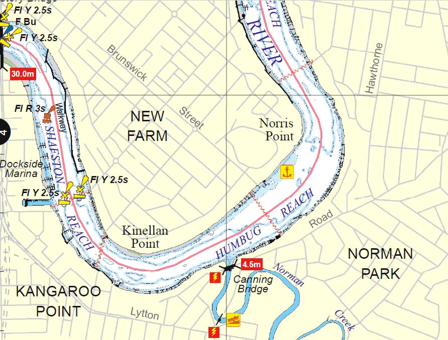
The Humbug Reach of the Brisbane River is approx. 25 km upstream from the river mouth, its downstream extent is Norris Pt, marked by the Brisbane Powerhouse & New Farm Park and the upstream by Kinellan Pt marked by Sydney St City Cat Terminal and Glenfalloch Apartments. The northern bank of the reach is New Farm, and the southern bank is Kangaroo Pt and Norman Park. The northern bank is manly residential together with the Merthyr Bowls Club, the home of barefoot bowls New Farm Park and the Powerhouse arts, theatre, and entertainment complex. The southern bank is residential and has Mowbray Park, Churchie College’s Graham Fowles Boathouse, the heritage listed Canning Bridge which carries Lytton Rd over Norman Creek a tributary of the Brisbane River, and Lourdes Hill College stands on the high ground at the downstream limit of the reach.
Humbug
“Humbug” was a slang or swear word and used in the 1800s by the mariners whose sailing ships became becalmed on this stretch of the river and needed towboats to tow them up to the city wharves. In earlier times the river front of part of New Farm was called Amity Point & Humbug Point “on account of the uncertain behaviour of the tide or currents there”
Norris Point
Norris Point named after the Norris family and first mentioned in 1876. In 1928 it became the site of the Brisbane Powerhouse. Part of Norris Pont also fronts New Farm Park which was opened as a park in 1919.
Kinellan Point
Is named after the home of Queensland’s 1st colonial Treasurer Sir Robert Mackenzie in the early 1860’s it being named after one of his clan’s residences in Scotland. Initially a single story it was enlarged to two stories in 1885. In 1890 the land was subdivided, and the house was demolished in 1929.
Mowbray Park
Is named after Rev Thomas Mowbray a Scottish preacher who set up a place of worship in 1851 for the parishioners east of Brisbane town. When he died in 1867 the 33.6 Ha of land was subdivided into 355 m2 residential lots to become the suburb of East Brisbane. The land for the park bearing his name was purchased in 1903. On the foreshore near the ferry terminal is the site of the river baths built in 1919 and it had its own Surf Life Saving club which was associated with the Burleigh Heads SLSC in the 1930’s. The baths were demolished in 1969 (remnant steps can still be seen)
Brisbane River
After the flood of 1893 there was a proposed scheme to re-align parts of the river to improve flow. This scheme involved a diversion cut thru the Kangaroo Point peninsular and then across New Farm near the intersection of Brunswick St & Merthyr Rd. If this had proceeded there would no longer be a Humbug Reach or any “Humbug Boats”.
“A River with a City Problem” by Historian Dr Margaret Cook is a good read about the workings of the river and its flood history
For those interested in greater details of the areas around Humbug Reach please visit: